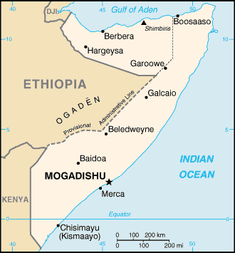
Somalia is a country located in the Horn of Africa which officially consists of five federal member states, namely Galmudug, Hirshabelle, Jubaland, South West, Puntland and the municipality of Benadir. It is bordered by Ethiopia to the west, the Gulf of Aden to the north, the Somali Sea and Guardafui Channel to the east, and Kenya to the southwest. With a land area of 637,657 square kilometers, Somalia's terrain consists mainly of plateaus, plains and highlands. Its coastline is more than 3,333 kilometers in length, the longest of mainland Africa. It has been described as being roughly shaped "like a tilted number seven".
In the far north, the rugged east–west ranges of the Ogo Mountains lie at varying distances from the Gulf of Aden coast. Hot conditions prevail year-round, along with periodic monsoon winds and irregular rainfall.[6] Geology suggests the presence of valuable mineral deposits.
Somalia is separated from Seychelles by the Somali Sea and is separated from Socotra by the Guardafui Channel. Non speaker of Somali language are (1) wazigua, (2) Bajuni, (3) Barwani (4) Booni, (5) Tunni (ethnic Somalis who speak a different but closely related language to their fellow Somalis), the first 3 ethnic groups speak Bantu languages whilst the last two speak Cushitic languages.


No comments:
Post a Comment